- HOMEPAGE
- STALBRIDGE EVENTS
- NEWS ITEMS
- SHOPS IN STALBRIDGE
- FOOD & DRINK
- activities
- SERVICES
- ABOUT STALBRIDGE
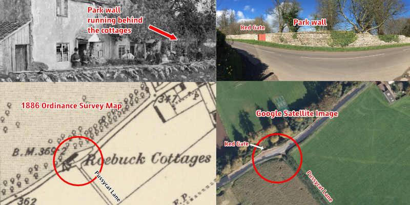
- STALBRIDGE HISTORY
- Contact Stalbridge Info
- SEARCH FOR SOMETHING
- STALBRIDGE SOCIAL MEDIA
- TEST PAGE
- A to Z OF ELECTRICIANS, PLUMBERS AND BUILDERS ETC
- APPLIANCE REPAIRS
- ACCOUNTANTS AND TAX
- ANIMAL FEEDS
- Stalbridge Artists
- AUTHOR
- BEAUTY
- BED AND BREAKFAST IN STALBRIDGE
- BOARDING KENNELS
- BOILER SERVICING - GAS AND OIL
- BOOKS
- BOUNCY CASTLES
- BUILDERS
- BUILDING SUPPLIES
- CAKES AND PIES
- CAR AND VEHICLE REPAIRS AND MOT
- CARPENTRY AND JOINERY SERVICES
- CARPET CLEANING
- Carpet and Upholstery Cleaning Services in Stalbridge
- CARPET FITTERS
- CHARITY SHOPS
- CHIMNEY SWEEP
- CLEANING SERVICES
- COMPUTERS
- DISCO
- Dog Day Care Services
- Dog Grooming Services
- ELECTRICIANS
- Event Planners
- FLORIST
- Funeral Directors
- GARAGE DOORS
- GARDEN CENTRE
- GARDEN CLEARANCE
- GARDEN MACHINERY SALES AND REPAIRS
- GARDENING SERVICES
- GREETING CARDS
- GIFTS
- GLASS AND GLAZING
- HABERDASHERY
- HAIRDRESSERS
- Heating Oil Suppliers
- HOUSE CLEARANCE
- Kennels and Catteries
- LANDSCAPING
- MAN AND VAN
- MARQUEE HIRE
- Oil Heating Safety
- PAINTER
- Patio, Decking and Driveway Cleaning Services in Stalbridge
- PEST CONTROL
- Picture Framers
- PLASTERER
- PLUMBER
- PHOTOCOPYING
- PHOTOGRAPHER
- PRINTING
- REMOVALS
- ROOFING SPECIALISTS
- SEWING AND SEAMSTRESS
- SIGN AND BANNER PRINTING
- SKIP HIRE
- SOLICITOR
- SPORTS MASSAGE THERAPIST
- Stalbridge device repairs
- STATIONERY
- TOOL HIRE AND SALES
- Travel Agents
- TREE SURGERY
- Tyres and Batteries
- VETS
- Vehicle Transport Services
- BOBS VEHICLE SERVICES OF STALBRIDGE
- VINTAGE AND CLASSIC CAR AUCTIONS
- WEBSITE DESIGNERS
- WINDOW CLEANER
- WINDOWS AND DOORS
- FOOD CLUB AT THE GUGG
- PRIVACY POLICY
|
|
|
|
© COPYRIGHT 2012-2023. ALL RIGHTS RESERVED. WEBSITE DESIGNED, BUILT AND EDITED BY FIELDHOUSE WEB DESIGN OF STALBRIDGE
STALBRIDGE INFO IS GENEROUSLY SUPPORTED BY STALBRIDGE TOWN COUNCIL